Tweet Manookatoo Adventures: July 2020

Monday 20 July 2020

Escaping winter


A busy port
Townsville is the largest city in northern Queensland and we spent a week there, at the Townsville Yacht Club Marina, restocking our supplies and getting a few minor repairs done. After ten days in Horseshoe Bay, with the small swell a constant, it was nice to spend some time in the serenity of a boat harbour! We took the opportunity to have dinner with Chris and to borrow his car, useful for organising repairs and restocking at shopping centres too far to walk or ride to. We also spent some time exploring the city sights on foot or bicycle, particularly enjoying the Sunday morning markets in the main street. By the following Monday all was well and we were ready to cruise the oceans again. As well as hosting the small marina, Ross Creek is the main port for Townsville. A "traffic light" operates when large ships are docking or departing and all boating traffic, including the Magnetic Island ferries, must wait in line! Fortunately as we cruised down the creek, no other ships or ferries were moving.
Along the Strand, Townsville
Market Day
Along the Strand, Townsville
Seagulls enjoying Horseshoe Bay
We enjoyed a couple of nights on anchor at Magnetic Island, taking strolls along the beach each day and enjoying sundowners at the Marlin Bar each afternoon. We bought a few seafood supplies at the general store in Horseshoe Bay; the prices and quality are really good and it’s nice to support the locals. Now that Queensland school holidays are over, crowd numbers have dwindled so the tourist offerings and restaurant hours are also reduced. There are still quite a few boats here, including fishing boats with crews resting by day and the boats disappearing at night to their fishing grounds further afield.
By Wednesday morning we were ready to move on, raising the anchor at first light and continuing northeast, past Palm Island and Fantome Island to Orpheus Island, cruising beside Yanks Jetty, the exclusive resort and the research station, picking up a mooring in Little Pioneer Bay, just near the reef. We enjoyed prawns we had purchased in Horseshoe Bay for lunch, then took the dinghy ashore to check out the camping facilities and see if we could find the walking track, reportedly overgrown since we last ventured there. A couple from a nearby boat were drawings watercolours of the bay, and they told us they had recently done the walk, so we are confident we can find it in the morning. A calm and pleasant night followed; while it is cool and clear outside, we enjoy dining “al fresco” when there is no chilly breeze!
Lucinda sugar jetty - 5.6km long
A slight breeze from the southeast was predicted overnight, from which our mooring was protected by the hills of the island - however, the wind strengthened and pushed around to the southwest, waking us soon after midnight with thumping waves rocking the hull. Our plans to stay here two nights were quickly changed! After breakfast and a few chores we got in the dinghy to go ashore and walk to the top of the island, however a dropping tide and shallow drafts over coral made us concerned about what we might face on our return, so we abandoned that plan too!
The beautiful Hinchinbrook channel
Later, we watched a fin circling around above the coral - remembering that last time we were here, we went snorkelling there, gave us quite a shiver! After an early lunch we raised the anchor and headed northwest, passing the 5.6 km long sugar conveyor on our way into the Lucinda channel, before turning north into the Hinchinbrook channel. The mystical high mountains rise on either side and we cruised along, dropping anchor beside Haycock Island just before 4pm. Tonight, no winds will disturb our sleep, however the temperature dropped considerably after the sun went down, and we retreated inside for dinner.
The silted up Marina - Cardwell
On Friday morning, after a peaceful night, we started the day with our exercises, then, after breakfast, we continued north up the Hinchinbrook channel. The water was still and conditions were perfect. At the northern end of the channel is Cardwell, right on the Bruce Highway. The marina complex has silted up after flooding rains from a cyclone - there are boats still there so the channel must be navigable at high tide, but when we passed even the channel markers were on the mud. Our plan was to take the dinghy to shore but the water shallows over mud quite a long way from the shore so we abandoned that idea! We returned to Manookatoo and had lunch in the calm waters before continuing north, arriving at Dunk Island and anchoring off Bammo Bay just after 4pm.
Coconut Beach, Dunk Island
Saturday morning we woke refreshed after a calm night on anchor, heading ashore soon after breakfast with a view to climbing to the summit of Mt Koolamatoo. We have walked this track before, it is nice and smooth but travels relentlessly uphill, so it is a pleasure to stop at the summit and enjoy the view! We had planned to continue down and back to the boat, however the day was so pleasant that the longer island circuit walk tempted us and we continued following the (not so smooth) track down the eastern side of the island and onto Coconut Beach, eventually returning to Manookatoo in time for lunch and feeling a great sense of achievement after our 11km trek! A well earned rest and a delicious three course dinner rounded out our Saturday.
Admiring Manookatoo from Fitzy's
Sundowners, Fitzroy Island
Sunday dawned smooth again and, just before 6:30am, we raised the anchor. Today was a full cruising day, with Fitzroy Island our destination. Conditions were very good, with just a slight swell on the starboard stern keeping us on our toes. We passed a couple of likely anchorages as we cruised along: Mourilan Harbour, where a large sugar terminal is surrounded by calm, smooth waters and the Frankland Islands, with courtesy moorings, camping grounds and a lovely looking lagoon for snorkelling over the reef. We may stop there on our way south. We arrived at Fitzroy Island just on 4pm, picking up a courtesy mooring on the western side of the ferry channel. Once we were satisfied with our position, we jumped in the dinghy for a drink at Fitzy's Bar, a favourite we remembered from our previous cruise. We feel a great sense of achievement to have reached the northern tropics and look forward to continuing on to new destinations in the coming weeks.


Captain's Log: Townsville to Cairns
Distance travelled: 189.1 nautical miles
Fuel consumption: 183 litres
Cruising hours: 30 hours 10 minutes


Monday 6 July 2020

Magificent Magnetic Island


Beautiful Horseshoe Bay
Saturday is the first day of the school holidays and it is obvious that Magnetic Island is reopened for business! Many boats cruised in during the morning, the JetSki and hire boat business is doing a roaring trade and there are kids frolicking in the swimming enclosure. After breakfast we took the dinghy to shore and walked the 2.5km stretch of sand to the northern end of the beach. We returned to Manookatoo for lunch and a lazy afternoon, watching the world go by - and happy to be out of the thick of it!


Picnic Bay
The Sunday markets were just starting when we took the dinghy ashore in the morning, and after a look around and a small purchase, we boarded the bus across the island. Our first stop was Nellie Bay, where the ferry comes and goes from Townsville. Being school holidays, there were lots of passengers. We wandered around Nellie Bay and stopped for a delicious coffee at "Scallywags" before boarding the next bus and continuing our journey to the end of the line at Picnic Bay. This used to be where the ferry terminal was, but it is now a sleepy village with a lovely pub overlooking the old jetty. We enjoyed lunch there, watching the world go by, before boarding the bus again for the trip back to Horseshoe Bay. Magnetic Island is mostly National Park, very mountainous and undeveloped on all but the south-eastern side. The bus chugs up and down the many hills between each town; there are walking tracks, but none of them are very easy!

Enjoying the views
The view over Arthur Bay
On Monday we tackled a more challenging walk, we caught the bus to the Forts carpark and walked down the hill to Arthurs Bay. From there we walked up the next hill, enjoying the view on the way, before descending again to Florence Bay. The old road continued around past Georges Bay and along to Radical Bay, where it finished and the "real" hard work began! We climbed up the boulder-strewn hill and crossed the saddle before heading off the main track and down to Balding Bay - another rocky track! After a refreshing cup of tea we retraced our steps up the track and continued down until we reached Horseshoe Bay again. It was 6 kilometres of quite picturesque but reasonably difficult walking - although we passed a runner on the road and he overtook us on our way up the rock-strewn track, so maybe it wasn't as hard as we thought it was! It was good to get back to the beach for a well-earned swim before returning to the boat for a rest.

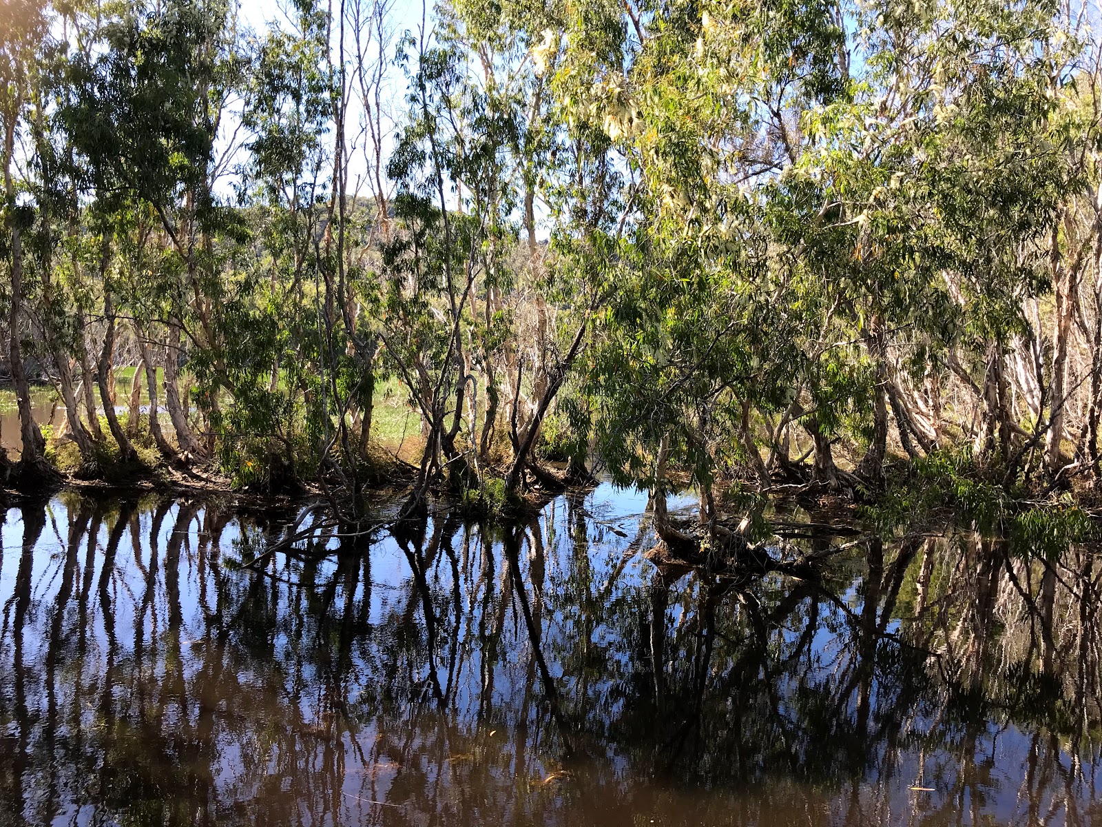
Horseshoe Bay wetlands
On Tuesday we chose a new walk, to the wetlands behind Horseshoe Bay. It was a tranquil scene, away from the busy beach and streetscape and we wandered along the boardwalk and through the bushland, emerging onto Horseshoe Bay beach well north of the village and wandering back along the sand. Very few tourists venture up this far on the beach, which stretches for more than 2 kilometres. A horse stud runs occasional tours with gallops along the sand, fortunately not while we were there!

Nellie Bay to Arcadia walk
We boarded the bus again on Wednesday, travelling to Nelly Bay and walking the streets before taking the main road back over the hill to Arcadia. The path is right next to the road, separated by a steel fence and extending out over the cliff edge. The views are spectacular! The walk continues over the mountains, through the bush to Horseshoe Bay, however we have done that before and know how tough it is, so we waited for the bus to take us back. The road is so steep that standing on the bus is banned - at busy times they have two buses following each other so that everyone can have a seat.

Boat cleaning day!
 We decided to have a rest day on Thursday, enjoying a stroll along the sand south of the village. Three boats had come into shore on the high tide and were now resting on the sand, their owners busy cleaning under the hulls before the tide came in again. This is not something we can do on Manookatoo but it is a cheap way to clean a catamaran or other flat-bottomed vessel. Some boat residents live on very little money, anchoring offshore permanently and only going ashore to buy supplies or cart water or fuel in jerry cans via their tender - we admire their resilience and resourcefulness!

 
We boarded the bus again on Friday morning for the short uphill trip to the Forts car park. The walk to the Forts is one we have done before, it is a steep climb up an old road to see the ruins of the first lines of defence during the Second World War. It also offers spectacular views over the bays and headlands. On the way up we saw a koala and baby nestled in a tree and heard kookaburras laughing at us from the nearby canopy. A large group of people were flying a drone around the vantage point at the top, the noise was like a thousand mosquitoes coming into land, so we didn’t linger! We walked back down the hill to Horseshoe Bay, then freshened up for a lovely long lunch at Barefoot Gallery with Yvonne and Andrew from Tranquility Base; we have enjoyed our time together in the bay but they are continuing north tomorrow.

Farewell Tranquility Base
Tranquility Base left early the next morning, but many boats soon arrived to take its place. This is a long weekend in Townsville, so many locals have taken advantage of the island’s close proximity to come and visit! The local tourist venues were doing a roaring trade, with speed boats towing screaming kids on tubes, kayakers, paddle boarders and jetskis as well as the “Island time” tour boat doing the rounds. We spent very little time ashore over the weekend, preferring to enjoy the serenity as best we could away from the crowds.


The wild side of “Maggie”
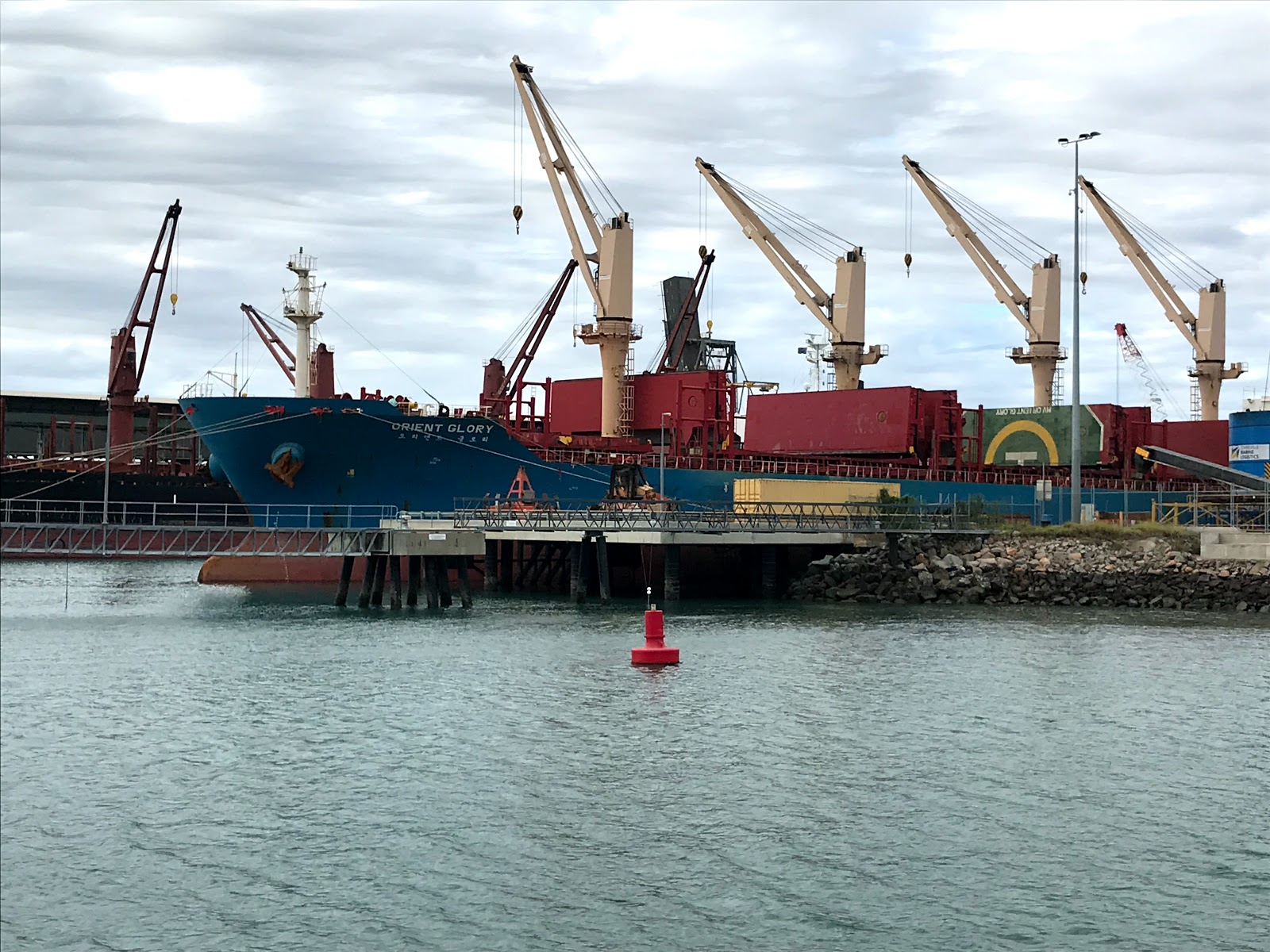
Approaching Townsville 
On Monday, Townsville show day, we raised the anchor to head around the island anticlockwise and cruise across to Townsville. The western side of Magnetic Island is wild and remote, with rocky cliffs stretching down to the water. The passage between the island and the mainland is not deep enough for large vessels, so for us it is a nicer trip than the main shipping channel, where the ferries also run. After twelve days on Anchor, most of those on the island, it is time to restock the boat and get a couple of repairs done.

Saturday 4 July 2020

North to Townsville

Approaching George Point
Sunset, Edgecumbe Bay
Our stay in the Whitsundays was a (mostly) windy one and eventually, on the Sunday of the winter solstice, we gave up trying to visit the outer reef and headed north from Woodwark Bay. Apart from one lumpy section just before we rounded George Point, the wind and sea state worked in our favour and we made good time, passing through the Gloucester passage and around Shag Islet just after midday, picking up a mooring outside the Gloucester Eco Lodge. We made our way ashore soon after, and enjoyed a lazy lunch and an afternoon of music on the deck, looking over the water and contemplating our good decision making!
Sundowners, Gloucester Eco Lodge
Gloucester beach

Monday dawned sunny, clear and calm. After breakfast we took the dinghy ashore again for a long walk on the sandy shore. There were a few fishermen about and we could see holidaymakers in some of the waterfront cabins; it is good to see the area is opening up again. We enjoyed a lazy day, revelling in the warm conditions, heading over to the Eco Lodge again in the afternoon for a swim in the pool and a sunset drink. A quiet evening followed, watching Apple TV - no local reception here! 
Farewell Bowen
It was time for a short cruise on Tuesday across Edgecumbe Bay and into Bowen marina. We had enjoyed our last visit in 2017 and were keen to explore the town again. Unfortunately some of the shops were closed; whether permanently or due to current restrictions was unclear, but the town was certainly very subdued. We enjoyed lunch in the Larrikin hotel, one of only two venues open today, it was very pleasant sitting on the verandah enjoying the cool breeze. On Wednesday morning we walked the 2.8 kilometres to the local shopping centre to restock a few supplies, returning to the boat for an early lunch and then leaving the marina to refuel the tanks, something we had not done since Bundaberg. We cruised out past the North Point lighthouse and around Cape Edgecumbe into Queens Bay, where we dropped anchor for the night. There was a slight breeze and a small swell but we found the motion quite relaxing, and had no trouble sleeping that night!
Approaching Abbott Point
We raised the anchor at first light on Thursday morning, cruising out of Queens Bay in a rolling sea, making our way north past Abbott Point just as a ship was docking for coal loading. Two more ships were anchored offshore but it was nowhere near as busy as Hay Point to the south of Mackay. We rounded the rugged Cape Upstart, so named by Captain Cook because it is such a dramatic landscape. Entering Upstart Bay we followed the coastline and dropped anchor about halfway down the bay; it shallows quickly with a rocky shore so we were careful with choosing a suitable spot! After lunch we took the dinghy to shore, anchoring it off the sand so that it would still be floating after our walk, ambling along the sand and over rocks, through shallow inlets and past holiday shacks. The beach is largely made up of coral and we wondered where it originated from. We returned to Manookatoo and enjoyed lazing as the boat gently rocked in the sea.
Sunset, Cape Upstart
Sunrise, leaving Cape Upstart!
Another early start on Friday, with the plan to stop just before lunch at Cape Bowling Green; usually, we enjoy cruising in the morning and exploring in the afternoon. But Bowling Green Bay is quite different to Upstart: a long, flat spit of sand is all that protects you from the ocean and the bay itself is shallow, with many shifting sand bars. With fresh south easterly winds forecast, we wanted to be well in the bay for protection, requiring at least an hours’ cruising in (and back the next morning). As Magnetic Island is less than five hours north of there, we changed our mind and decided to keep going! The seas were calm and the sun was shining, making for a very pleasant day of cruising and we enjoyed pre-lunch nibbles and open sandwiches on the fly bridge as we watched the coastline go by. We rounded Cape Cleveland just before 4:00 and continued across the bay to Magnetic Island, dropping anchor in Horseshoe Bay just after 5pm. A magnificent sunset and a calm, relaxing evening convinced us we had made the right decision. The weather is glorious here and we intend making the most of it, reliving memories of three years ago, planning to repeat many of the walks we did then and maybe even explore a couple more.
Magical Magnetic Island
The Captain's Log:
Distance travelled: 146.1 nautical miles
Travel time: 22 hours 35 minutes
Fuel consumption: 146.5 litres